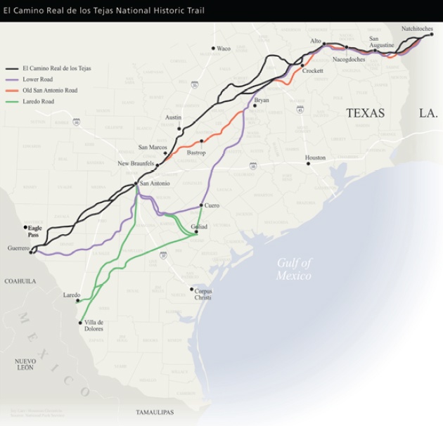
Historic Waterways Near the DFW Region
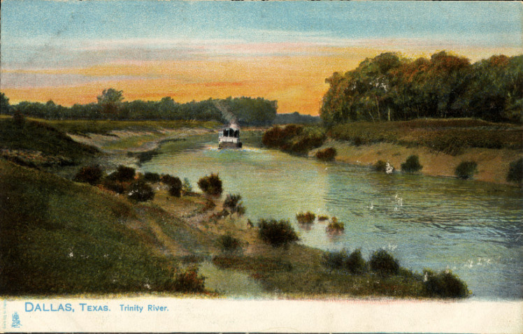
The Trinity River defines North Texas’ historic waterways, flowing approximately 710 miles from its headwaters in North Texas to Trinity Bay on the Gulf Coast. Its forks converge near Dallas and Fort Worth, shaping where both cities were founded and how they developed. Long before Anglo settlement, Indigenous groups—including the Caddo and Wichita peoples—lived, traded, and traveled along its tributaries.
In the 1860s, Dallas business leaders attempted to transform the city into a river port by stockpiling thousands of cotton bales along the Trinity’s banks. Shallow channels and unpredictable seasonal flow made sustained navigation unrealistic. Later, the devastating 1908 Trinity River flood reshaped regional water policy, ultimately leading to levee construction and a network of flood-control reservoirs that continue protecting the metroplex today.
Why the Trinity River Shaped Dallas and Fort Worth
When Major Ripley A. Arnold established Fort Worth in 1849 at the confluence of the Clear Fork and West Fork of the Trinity River, the location was chosen for defense and access to water. The river corridor offered a natural transportation route and a strategic military position on the frontier.
In Dallas, founded in 1841 by John Neely Bryan near a Trinity River crossing, proximity to water influenced early settlement patterns. While the Trinity never became a major commercial shipping artery in North Texas, it supported agriculture, livestock movement, and local trade.
Throughout the late 19th century, civic leaders proposed canalization projects to make the Trinity navigable to the Gulf. These efforts ultimately proved impractical due to fluctuating water levels and sediment buildup. Instead, railroads became the dominant transportation system.
In the late 20th and early 21st centuries, portions of the Trinity corridor were revitalized with parks and trails, including the Trinity River Audubon Center and Trinity Trails in Fort Worth, shifting the river’s role from industrial aspiration to recreation and conservation.
Elm Fork and West Fork: Tributaries Behind North Texas Expansion
While the Trinity River often receives primary attention, its Elm Fork and West Fork have played equally important roles in shaping suburban growth across the Dallas–Fort Worth region.
The West Fork Trinity River, flowing through Fort Worth, directly influenced the city’s founding in 1849. Early agricultural settlements and cattle operations relied on its water supply. Over time, flood control reservoirs such as Lake Bridgeport and Eagle Mountain Lake were constructed along the West Fork to regulate flow and support expanding communities.
The Elm Fork Trinity River, which runs through Denton County and western Dallas County, became central to suburban expansion in cities such as Carrollton, Irving, and Lewisville. The construction of Lake Lewisville (completed in 1955) along the Elm Fork provided both flood protection and a long-term municipal water supply, enabling rapid population growth in North Dallas suburbs.
Together, these tributaries shaped not just historic settlement but modern metropolitan expansion.
The Trinity’s Journey from North Texas to Trinity Bay
The Trinity River flows southeast through prairies, bottomland forests, and East Texas wetlands before emptying into Trinity Bay near Galveston Bay. The river drops roughly 1,000 feet in elevation along its course.
Steamboat traffic operated more successfully on lower sections of the river closer to the coast, though sustained navigation into North Texas remained inconsistent. Seasonal flooding and sandbars frequently interrupted passage.
While the river did not transform Dallas into a port city, it influenced settlement growth, agricultural development, and floodplain management across North Texas.
Indigenous Settlement and the Early Frontier
Before European-American settlement, Indigenous communities established villages and trade routes along Trinity tributaries. The Caddo Confederacy maintained agricultural settlements in East Texas, while Wichita groups occupied portions of North Texas.
Spanish colonial activity in the Trinity watershed was limited compared to East Texas and San Antonio. It was not until the Republic of Texas era that Anglo-American settlement accelerated.
Fort Worth’s founding in 1849 marked a turning point, as frontier military presence expanded into the Trinity River corridor. The river shifted from an Indigenous trade network to a boundary and settlement marker for expanding Texas communities.
The Cotton Port Dream That Never Materialized
During the 1850s and 1860s, Dallas leaders envisioned transforming the Trinity River into a navigable shipping route. Historical accounts describe thousands of cotton bales stored along the riverbank awaiting shipment.
However, inconsistent depth, debris, and drought conditions prevented reliable steamboat traffic. Unlike Houston’s Buffalo Bayou, which eventually developed into a deep-water port, the Trinity near Dallas lacked sustained navigability.
As a result, Dallas shifted its economic focus toward railroads. The arrival of rail lines in the 1870s positioned the city as a transportation and commercial hub without relying on river shipping.
Ferries and Low-Water Bridges: Crossing the Trinity
Before modern bridges spanned the Trinity River, early settlers relied on ferry crossings and low-water bridges to move people, livestock, and goods.
In the mid-19th century, private ferries operated at key Trinity crossing points near Dallas and Fort Worth. These ferries charged small tolls and were vital for wagons traveling between frontier settlements.
Low-water bridges—constructed of stone or timber—allowed passage during dry seasons but were frequently submerged during floods. Their vulnerability reinforced the need for improved infrastructure and later influenced levee and bridge construction throughout the metroplex.
These early crossings highlight how rivers shaped transportation challenges long before modern highways defined regional mobility.
The 1908 Flood and Regional Water Management
In May 1908, severe rainfall caused the Trinity River to overflow, flooding large sections of Dallas. Downtown areas were submerged under several feet of water, causing multiple fatalities and significant property damage.
The flood prompted large-scale engineering responses. The Dallas Floodway Project, guided by engineer George Kessler, led to the construction of levees completed in the early 1930s.
Over subsequent decades, federal and regional agencies constructed a series of flood-control reservoirs across North Texas. Major lakes serving flood management and water supply functions include:
- Lake Bridgeport (1932)
- Eagle Mountain Lake (1934)
- Benbrook Lake (1952)
- Grapevine Lake (1952)
- Lewisville Lake (1955)
- Joe Pool Lake (1986)
These reservoirs were not created directly by the 1908 flood alone but were part of broader long-term flood control and water supply planning throughout the 20th century.
Today, the Trinity River system remains central to regional infrastructure, water management, and recreation.
Lake Ray Hubbard and Lavon Lake: Expanding Eastward
As DFW expanded eastward, additional reservoirs became essential for flood control and water supply.
Lavon Lake, completed in 1953 along the East Fork of the Trinity River in Collin County, was constructed by the U.S. Army Corps of Engineers for flood control, water conservation, and recreation. It remains a major water source for North Texas municipalities.
Lake Ray Hubbard, impounded in 1968 on the East Fork near Rockwall and Rowlett, serves both municipal water needs and recreational use. Its development accelerated suburban growth in eastern Dallas County and Rockwall County.
These lakes illustrate how historic waterways evolved into engineered systems supporting modern urban development across the entire DFW region.
Modern Recreation Along Historic Waterways
Today, the Trinity River corridor supports recreation rather than commercial navigation.
In Fort Worth, the Trinity Trails system spans more than 100 miles of hike-and-bike paths along the river and its forks. The Trinity River Vision project has enhanced waterfront access, creating popular kayaking and paddleboarding areas.
In Dallas, the Trinity River Audubon Center and surrounding Great Trinity Forest offer hiking trails and wildlife viewing. Seasonal paddling routes operate on calmer stretches of the river when water levels permit.
These modern uses reflect a shift from industrial ambition to environmental restoration and community recreation, preserving the river’s historic role as a defining regional feature.
How the Trinity Forks Converge
The Trinity River system consists of four primary forks:
- West Fork – Originates in Archer County and flows through Fort Worth
- Clear Fork – Joins the West Fork in Fort Worth
- Elm Fork – Flows south from Montague County through Denton and Carrollton
- East Fork – Runs through Collin and Rockwall counties
The Elm Fork and West Fork converge west of downtown Dallas, forming the main Trinity River channel. Farther downstream, the East Fork merges near southeastern Dallas County, continuing southeast toward Trinity Bay.
Understanding this fork system clarifies why Dallas and Fort Worth developed where they did—each city grew around different branches of the same river network.